The past couple of days have been just getting things done, laundry, shopping, haircuts, things like that and mostly taking it easy.
Yesterday we took an early morning walk through the Wild Life Refuge The only wild life around was Dennis. (that's not a bad thing).
Our kitchen cabinets have shaken loose and appear to be at risk of falling. This is not an entirely new issue. This spring when we traveling through Texas they were shaking loose and were coming loose from the wall. So we fixed them by putting in a few screws and a couple of brackets. We said "let's see how that works" and promptly forgot about it. Now we notice that the same thing seems to be happening again. Well, we do not claim skills in carpentry and it is not obvious how this would best be done. So we spend a lot of time trying things that seem like they would help but in practice don't really seem to be doing what we want. So after further study we tighten up everything that we can and add a couple more brackets - hopefully better placed this time. We did get over some pretty bad roads before they came loose this time. We hope that this will hold them until we get a chance to replace them or get them fixed by someone with actual experience and/or skills in doing this kind of thing.
On Sunday we had contacted friends Barb and Mel Gibb about their property on the Kenai , they said that we could stay on the property but there would be no hook-ups. We took a drive in the am and were not able to locate the exact site, however, we did see a moose standing in the river. She was very accommodating by letting us take as many pictures as we wanted.
After returning to the bus, sent Barb an email and she replied back with the address and off we went again in the late afternoon and were able to locate the site. Really nice. On our return to the campground we had an up close encounter with a moose and her calf, was a close call.
We had thought we would go to Homer for a few days, but when we checked into campgrounds there, we found that they were either pricey or lacking in amenities. It also would have put us moving on or just before the 4th of July weekend. In the process of deciding what to do we happened to talk with the manager of the park here who said that we could stay here for a few days for the member extended rate which is not bad for this area, especially on a holiday weekend so we paid to stay at this park in Soldotna until the 5th. During our stay here we plan at least one more day trip to Homer. After that we will probably go to Mel and Barb's which is just a few miles away for a couple of days before moving on, probably to Seward.
Tuesday, June 30, 2009
Friday, June 26, 2009
The Western End of the Road
We drove down to Homer today for a day trip. It was a nice drive. On the way we stopped at Anchor Point and drove a mile and a half west on the Anchor River Beach Road to the most westerly point in North America accessible by the continuous road system. The longitude is W151° 52'.
The views of the mountains of the Aleutian chain across Kachemak Bay were especially beautiful. The best views were at a rest area view point just before entering Homer where the horizon is filled with the mountain peaks.
We drove the famous Homer Spit where we hope to camp for a few days next week. We also visited the Alaska Islands and Oceans visitor center. We didn't have enough time to see all of this excellent interpretive center but enjoyed the time we spent there and plan to go back.
Wildlife seen today included several bald eagles and two moose sightings, a bull moose and a cow. But no wildlife pictures.
Soldotna
We are in the Edgewater RV Park on the Kenai River in Soldatna for a week. We had an RPI reservation here for a week starting June 23. This was a good deal for us and although we had only a general itinerary to this point, we were focused on getting here by the 23rd which we did. The park itself is ordinary, but the $10/day price for full hookups in this part of Alaska is exceptional. The park has a short trail down to a ramp on the pretty and rapidly moving Kenai river. Immediately across the highway is an even better fishing and viewing ramp. This area is known for its great Salmon fishing. Even those without great skill often catch many fish here. We are just waiting to catch a big one.
Since we are here for a week, we are taking things a bit slower and catching up on a few things. We found a Home Depot in Kenai about 10 miles away and bought a few household things we needed. We repaired a broken drawer and Dennis made what turned out to be a minor repair on our generator. We also have spent a lot of time trying to get our Tom Tom GPS working right, with calls and emails to tech support. So far no luck with the Tom Tom which has caused us to make a couple of wrong turns. It is funny how quickly we can become dependent on new technology.
Today we made a trip in the car to the beach area at Kenai and the Captain Cook Recreation area about 20 miles further on. Later we took a drive to the end of Funny River Road through part of the Kenai National Wildlife Refuge. But the only large wildlife that we saw were a mother moose and her two young calves.
WOW CAN'T WAIT TO GET THE BIG ONE
Since we are here for a week, we are taking things a bit slower and catching up on a few things. We found a Home Depot in Kenai about 10 miles away and bought a few household things we needed. We repaired a broken drawer and Dennis made what turned out to be a minor repair on our generator. We also have spent a lot of time trying to get our Tom Tom GPS working right, with calls and emails to tech support. So far no luck with the Tom Tom which has caused us to make a couple of wrong turns. It is funny how quickly we can become dependent on new technology.
COOK INLET
Today we made a trip in the car to the beach area at Kenai and the Captain Cook Recreation area about 20 miles further on. Later we took a drive to the end of Funny River Road through part of the Kenai National Wildlife Refuge. But the only large wildlife that we saw were a mother moose and her two young calves.
Monday, June 22, 2009
On to the Kenai
We got a late start out of Valdez as we knew we would likely not be staying in a campground and no reason to hurry. We drove back up the Richardson Highway to the Glen Highway where we headed toward Anchorage. The road was paved but had some quite rough spots as we have come to expect. Traffic on this section of road was the heaviest that we have seen we were in southern British Columbia which is many miles ago. We were starting to look for places to buy fuel and surprised to find that they were very rare on this busier road. We pulled off at Palmer to fill our fuel tank which we did at $3.45/ gallon. Even though it was a bit early there was a Taco Bell next to the station and it sounded good so we had dinner there. We had been thinking of staying at the Walmart at Eagle River but had found that they don't allow overnight parking, so we called a Sam's Club in Anchorage as we heard that they did allow overnight RV parking in their lot. The person answering the phone put us to the manager who said that he would love to have us stay but that he couldn't because of a citywide ban on RV overnight parking in parking lots. We didn't think we felt like going past Anchorage so we found a nice overnight spot near the Matanuska River Bridge about a mile from Palmer and spent the night there. It was a pretty parking spot with the rapidly moving river and the mountains in the distance. Ironically, we found a message the next morning on Barbara's phone from friends from Texas that they were staying at the Sam's Club in Anchorage. So we missed seeing them but staying at what was certainly a nicer spot.
This picture is just before midnight, June 21, 2009
Nice morning view
The next morning we continued on toward the Kenai Penninsula. We delayed our start long enough that we would not hit rush hour traffic in Anchorage as we felt that driving in the unfamiliar city might be difficult. It turned out that going through Anchorage was a breeze. We enjoyed the pretty drive south from anchorage on the Seward and Sterling Highways. While driving along the scenic Turnagain Arm we ran in to our first extended rain which continued for the rest of the drive and most of the rest of the day. We have perhaps been lucky as we have had only a little rain here and there so far on this trip. The only large wildlife that we saw on this 2 day trip were 2 bear that were far out on the shore of the Turnagain. We were caught in our longest traffic delay of the trip on the Seward Highway. We waited in line for a pilot car at least one half hour and they spend another 15 minutes or so going through the one way construction area. We got to our destination, Soldotna, in the early afternoon. We had planned that we would stay in the parking lot of the Fred Myers store as it had been reported to welcome RVer to overnight there. That was quickly confirmed when we arrived. We read a sign indicating in what areas RVs may park. The easily accessible spot on the outside edge that we had pulled into was in one of those areas. So we were parked for the night. They had some reasonable rules and stated that RVs may park in the lot for up to 3 days. We have a reservation for the Edgewater RV Park in Soldotna for a week starting tommorrow, so we only plan to be here overnight. We spent some time shopping in the store which is similar to a Walmart, perhaps a little more upscale. It felt like we were back in civilization.
We have a good cell phone connection here and we returned a call to our grandchildren. They asked us about the earthquake. We did not know anything about it. We later found that the earthquake center in Willow, Ak. and felt in Anchorage had occured sometime when we were on the road near Anchorage. We laughed and said that if we felt anything we probably just attributed it to the rough roads.
Saturday, June 20, 2009
Columbia Glacier Cruise Tour
Today we took a cruise on the Stan Stephens Glacier and Wildlife Cruises out of Valdez. It was a cruise of about 7 hours to near the foot of the Columbia Glacier. We enjoyed the trip a lot and were able to see a lot of wildlife and scenery in the Prince William Sound and to learn about the local area.
Valdez is famous for being the terminus of the Alaska Pipeline which we saw from the boat, as well as being the site of 2 disasters. The area suffered the largest earthquake ever recorded in North America in 1964. That earthquake destroyed the town of Valdez which was relocated to its present site 4 miles away. We were able to see the site of the old town of Valdez which has largely returned to nature. The area is known at least as well for the huge oil spill that occurred when the tanker Exxon-Valdez went aground in 1989. Although signs of the oil spill are no longer visible to a casual observer it can still be detected. Many affected wildlife species have recovered from the effects of the spill while others have not or are still recovering. We saw the site of the spill. We saw a tanker being escorted through the area by 2 small boats which is one of the measures to reduce the risk of a recurrence. Valdez harbor was not affected by the spill due to a wind that came up several days later and carried the oil away from the harbor.
Among the wild life we saw were several humpback and fin whales. We also saw a number of porpoises. We saw bald eagles and a number of horned and tufted puffins. We saw otters, harbor seals and a very large group of sea lions.
The boat approached as close as possible to Columbia Glacier. Although Columbia began retreating and disintegrating only about 1980 it is retreating rapidly. The glacier is about 2000 feet high of which about 1800 feet is below sea level. The glacier has now retreated about 10 miles from where it was in 1980. It is a very fast moving glacier with the loss of ice estimated to be over a 100 tons of ice a day. The area we were in was covered with an tremendous number of ice burgs from the glacier. The amount of ice is huge when you consider that at close to 90 percent of an ice burg is under water. The ice was rapidly moving in mostly circular currents due to fact that the water from the melting glacier is fresh water and about 16 degrees cooler that the salt water of Prince William Sound.
This is one of many large icebergs floating in the water
It was a pleasant and surprisingly tiring day as we were mostly on our feet moving to look at one site or another during most of the cruise.
Valdez is famous for being the terminus of the Alaska Pipeline which we saw from the boat, as well as being the site of 2 disasters. The area suffered the largest earthquake ever recorded in North America in 1964. That earthquake destroyed the town of Valdez which was relocated to its present site 4 miles away. We were able to see the site of the old town of Valdez which has largely returned to nature. The area is known at least as well for the huge oil spill that occurred when the tanker Exxon-Valdez went aground in 1989. Although signs of the oil spill are no longer visible to a casual observer it can still be detected. Many affected wildlife species have recovered from the effects of the spill while others have not or are still recovering. We saw the site of the spill. We saw a tanker being escorted through the area by 2 small boats which is one of the measures to reduce the risk of a recurrence. Valdez harbor was not affected by the spill due to a wind that came up several days later and carried the oil away from the harbor.
Among the wild life we saw were several humpback and fin whales. We also saw a number of porpoises. We saw bald eagles and a number of horned and tufted puffins. We saw otters, harbor seals and a very large group of sea lions.
This a humpback whale
bald eagle on top of the tree
Anderson waterfall
sea lions sleeping
The boat approached as close as possible to Columbia Glacier. Although Columbia began retreating and disintegrating only about 1980 it is retreating rapidly. The glacier is about 2000 feet high of which about 1800 feet is below sea level. The glacier has now retreated about 10 miles from where it was in 1980. It is a very fast moving glacier with the loss of ice estimated to be over a 100 tons of ice a day. The area we were in was covered with an tremendous number of ice burgs from the glacier. The amount of ice is huge when you consider that at close to 90 percent of an ice burg is under water. The ice was rapidly moving in mostly circular currents due to fact that the water from the melting glacier is fresh water and about 16 degrees cooler that the salt water of Prince William Sound.
This is one of many large icebergs floating in the water
It was a pleasant and surprisingly tiring day as we were mostly on our feet moving to look at one site or another during most of the cruise.
Thursday, June 18, 2009
On to Valdez
We started our day by getting our mail from general delivery in Tok, stopping at the Visitor Information Center and buying a couple of items at the local food market. Then we head down the Glenn Highway/Tok Cutoff toward Anchorage, then took the Richardson Highway to Valdez. Total miles were about 250, more than yesterday but an easier and quicker drive.
This was another pretty drive with several nice places to stop for a night or two by we wanted to get to Valdez. We saw a large animal back off the road that we are pretty sure was a buffalo but it was only a quick look. No other wildlife. The Worthington Glacier was among the best scenery.
Valdez is a small town but with a population of around 4000, it is one of the larger ones we have been in for a while. It is a beautiful place with the bay, boat harbor and snow capped mountains surrounding it.
We are at the Bear Paw RV Park. Although we are the largest RV in the park it easily accommodates large RV's and is full service with wifi and cable tv included in the price. It is about $10 a night less than another large park that seems to cater to large RVs. The best part is that we are only a block from the Harbor which is a pleasant view. Perhaps even a better choice would be Bear Paw Adult Park which overlooks the water and is essentially an annex of this park. We were under the impression that we could not get wifi if we parked there but we told later that all the services available here are available there too. In any case we are happy to be here for 4 nights.
Tuesday, June 16, 2009
Top of the World to Alaska
We decided to wait til a bit late to leave Dawson City to avoid a long wait at the Yukon River ferry. It didn't work well. We got to the ferry about 11 and still had to wait about an hour.
Across the river we started the famous/infamous "Top of the World Highway". The road goes up giving views of the river and islands. Then it goes on for miles essentially on mountain ridges. We were lucky to be on the road on a day that was clear and sunny. The scenery is varied views of valleys and various mountain ranges near and far.
The road on the Canadian side was unpaved the majority of the way but otherwise no worse than others we have been on.
We crossed into Alaska, this time with the bus, Roxie and more or less all of our worldly possessions. So we made it for sure.
The road on the Alaska side was narrower, unpaved and generally less well maintained. You need to understand that these roads have no berm and there are no guard rails anywhere. This is in an area where there are soft shoulder signs periodically on the narrow, winding roads up and down steep hills with areas of sharp turns and often steep drop offs. As you might imagine, meeting another vehicle in these areas is a challenge. Fortunately volume of traffic is small and we didn't meet other vehicles very frequently. Usually both vehicles will slow way down and quite often one of the vehicles stops at what is hopefully a slightly wider point in the road and the other can crawl past managing to stay on the road without hitting the other vehicle. Progress on the American side especially was very slow. We probably did not average more than 20 miles per hour.
Lore has it that you are likely to suffer damage to windshields, headlights or other areas on the front of the vehicle. We did not seem to have any such damage and did not use any rock guards, mud flaps or other attempts to protect our tow car which would be at highest risk. Our only defense was to drive slow and carefully. We did get very dirty though. We were covered with dust and even our bay compartments and engine compartment were covered inside with dust.
We passed by the tiny but somewhat famous town of Chicken, Alaska without stopping. Apparently many stop to sort of celebrate having made it over the "Top of the World". We weren't ready to stop for the night and talked of maybe stopping for coffee but decided that it looked like just another tourist trap and more trouble than it would be worth so we drove through and stopped along the road and made some coffee and took a break by ourselves. A few miles after Chicken the road was paved except for a few gravel sections and frequent rough spots. So instead of moving along at 20 miles per hour or so we could go at 50 or more then slow suddenly for the bad spots. Still it was a relief to be on something approaching a normal road.
We decided to push on to Tok. Which we did but only after a detour. It seems hard to believe that we could turn the wrong way at a major intersection but we did. Our GPS had been off track during the afternoon but it had never before told us to turn the wrong way at a major intersection so when it said turn left when we thought we should turn right, we talked about it for a minute and decided that "it must be right". So we turned left and immediately saw a sign telling us we were going the wrong way. So we drove 7 miles to find a place where we could take off the car and carefully turn the bus around without going off the road.
So we arrived in Tok perhaps not in the best mood, noting that fuel prices were higher than expected. We went to a campground that our guide indicated would meet our needs for a moderate price. They wanted $30 for a basic electric hookup site. When we objected they said they had sites with no electricity for $20. In some circumstances these are not high prices, but we felt that in the middle of nowhere with no tourist attractions or other draw we decided to look for something else. So we went to the Chevron Station one of at least 2 fuel stations offering a free nights parking if you buy fuel. We bought 60 gallons of diesel fuel for $3.79/gallon which is typical of this town and according to a couple of Alaskans not atypical of Alaska. The 60 gallons will get us to Anchorage (even with our planned detour to Valdez) the one place in Alaska that we have been led to expect to find cheaper fuel. The parking behind the Chevron Station was back in spaces with picnic tables and away from traffic. We were even able to get an unsecured wifi signal. The high point of our evening was a meal at Fast Eddies that was tasty, filling and affordable.
Monday, June 15, 2009
Dawson City
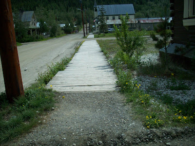
Dawson City is in a sense frozen in time. Everything here tends to reference the Klondike Gold Rush which started after the discovery of gold at Bonanza Creek near here in 1896. Many of the buildings maintain the appearance of that era. Another feature of the area is adaption to the cold climate. The permafrost is an issue in any construction. Houses are built on wood pilings that may periodically need to be adjusted to level low areas every few years. Nearly all streets are unpaved and sidewalks are wooden in deference to the effects of thawing and refreezing. The following photo shows a typical street and sidewalk.
The old post office pictured below is one of the sturdier examples of architecture from the Gold Rush days.
Below is a picture of the street in front of the Palace Grand Theater where we attended a live show and watched a free movie both of which were about the dance hall girls of the Klondike Gold Rush.
Sunday, June 14, 2009
Klondike Highway
After four days in Carcross, we left and headed north on the Klondike Highway. Again we took our time and left late. We stopped for fuel at a Fas Gas at the edge of Whitehorse and found that the price of at 95.9 a liter was less than at the Highway 37 junction where we had done a partial fill. In addition, we filled out a Fas Gas discount form and got another 3 cents a liter (a bit over 11 cents a gallon) off. We went on to the Whitehorse Walmart (the only one in the Yukon). The store seemed overpriced and difficult as it was not organized to our expectations, but we spent 2 hours and a lot of cash there as we had not been in anything larger than a convenience store for over a week.
On the Klondike Highway the only wildlife we saw were birds and what appeared to be a small fox. There was a stretch of road where we saw many signs warning to watch our for elk but we saw none of them. Apparently this is not a good time of year for seeing Elk or Caribou. There were areas of striking scenery. At one point there was a sign indicating that we were entering Beringia. This is a large area that includes the western Yukon, most of Alaska and Eastern Siberia. Interestingly, although it is an area that many of us would think of as the frozen north, it was not covered by Glaciers during the last Ice Age when most of Canada and much of the U.S. were. The level of water in the oceans went down allowing considerable interchange of plants and animals between the new and old words.
We are trying to do some sight seeing as we travel, so we pulled into an interpretive center museum, only to find it closed on a late Saturday afternoon. We are careful where we pull off because a 40 foot long wheelbase bus towing a car does not maneuver well in tight areas. To make matters worse you cannot back up without doing damage to the car or tow bar. We swung wide to complete the circle going outside a tree and inside a survey marker post but we were about a foot too far outside to clear the post. By then the car and bus were at an angle that made it likely that unhooking the car would likely be a time consuming and frustration ordeal. We tried pulling the post to the side but it would not lean enough to help. After starting back to work on unhooking the car, we turned and made an attempt to pull the post out and it started to give way. It was in deep but gradually came out. We were then able to drive by easily and push the post back in the hole and continue on our way.
We drove on to the tiny town of Pelly Crossing and stopped at a large pullout with the Selkirk Gas Bar (a convenience store/gas station" and the Selkirk Heritage Center run by the Selkirk Indian community. We spent a few minutes at the Heritage Center and were discussing where to stay. There was a free no hookup campground across the street but we were not sure we wanted to unhook our car for a quick overnight in the back in spaces. We were discussing this when an employee of the Gas Bar said that we could park in a quiet spot between the Gas Bar and Heritage Center and pull out easily in the morning. We decided that would best meet our needs, and he invited us to use the store WiFi which reached our coach easily.
From there we had an easy drive to historic Dawson City. We had identified the Guggieville RV Park at the edge of town as being the one most likely to meet our needs at a reasonable price. We missed it on the way by due to poor signage and had to drive the 2 km into town to turn around. When we got to it the sign said to go to the Bonanza Gold Motel and RV Park to register. So we turned around again (easily this time) and went to the Bonanza. They said they owned both parks and that to stay here was best. We pointed out the the guide book said the other was significantly cheaper. They offered us the services we wanted for the price we had at Guggieville so it worked our fine. We plan to stay here between 2 and 4 nights before taking the ferry to the famous "Top of the World" highway and on to Alaska.
Friday, June 12, 2009
Atlin, B.C.
We backtracked a bit today and visited Atlin in our car. The road to Atlin from the Alaska Highway was gravel about half of the way but in good shape. Traffic was light. There were great views of scenery.
This a really nice sign along the road.
Even the rest areas were nice.
We stopped to look for mountain goats at a viewing area but did not see any.
We saw several bears on the drive. A young grizzly on the side of the road.
A large back bear crossed the road in front of us on the way back. We had a good view of a mother grizzly with 2 cubs. Big Momma grizzly with two new cubs, didnt seem to even notice the number of cars taking photos of them as they grazed along side of the road.
The town overlooks beautiful lake Atlin. We had an excellent lunch at a small restaurant on first street. These are some pictures from Atlin. This is an old tour boat at Atlin.
Roxie and Barbara took a short break on this psychedelic bench down by the old tour boat.
Thursday, June 11, 2009
Mushing in Carcross
We spent the day today in Carcross. The highlight was going to Caribou Crossing Wildlife Museum and Attractions Center. They have an excellent taxidermy display of Yukon and Alaska mammals including Ice Age mammals.
We took advantage of the opportunity to take a dog sled (actually cart) ride with a team of dogs belonging to Michelle Phillips who is training for the Iditerod. The 5 dogs pulled the cart with 3 people surprising fast and were controlled only by a foot brake and voice commands. The five dogs pulling our cart were Tracker and June the lead dogs, Fuzzy and Ry in the middle and K2 was the brake dog.
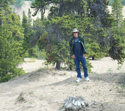
We stopped what is billed as the world's smallest desert with an oddly varied wind swept terrain.
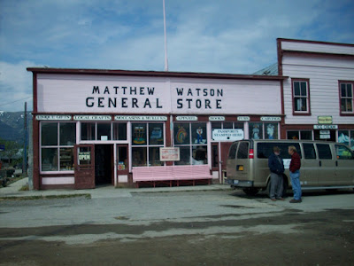
We visited the historic railway station, hundred year old general store, a surprising helpful visitor information center, and visited the local post office which is the only one in Canada that is open seven days a week. We were able to get a nice stamp on our passports there.
We took Roxie to the mile long beach on Bennet Lake. She loved it a good chance to run and run and run. Oh yea she liked the water too.
Wednesday, June 10, 2009
Skagway Side Trip
We made a day trip in our car today from Carcross, Yukon to our second Alaska town, Skagway. The trip there was the best part. It is over a mountain range with great views of the snow capped mountains, lakes, islands and forests. There were low lying clouds at points and areas of ice cover on the lakes. It looked at times like we think the Himalayas would look. The snow and clouds created at times an eerie moonscape type effect. We crossed into Alaska and got the firsts stamps on our passports, and crossed back into Canada quickly on our return. The town of Skagway is a small town filled with tourists from the cruise ships that land there. There are numerous tours by bus or train to see the area. In addition to the usual t-shirt and souvineer shops, there were many jewelry shops. We had a mediocre lunch at one of several restaurants on the main street.
Although there are some RV parks in Skagway, we elected to drive the car to save the fuel and trouble of driving the bus over the mountains and back for short visit. We probably would have seen more of the town if we had spent a couple of nights there but this way worked for us. In our view Skagway is definitely worth a visit.
We saw our first grizzly on our way back and were able to get this quick shot before it ran.
The Yukon has impressive signs when you enter. We did not get a picture the first time we came in, so we stopped this time.
Tuesday, June 9, 2009
Signs of Yukon
We got up early and continued up the beautiful but increasingly rough Cassiar highway. Another long patch of gravel road was followed by various rough spots, spot repairs, and short stretches of gravel road. The constantly changing condition of the road made it difficult to drive. We could not keep the GPS attached to the windshield as the bumps would shake it loose. We also had a support holding a cabinet shelf break and our printer fell and may be damaged.
The highlight of this segment was seeing two Bighorn Sheep just along the road. We were able to get a picture of one of them.
.
We crossed into the Yukon and reached the junction with the Alaska Highway and got fuel. At $1 a liter for diesel, the price was the highest I've seen this year, so I bought just enough to get to Whitehorse with the idea that the price will be lower in a larger city - that remains to be seen. We got permission to leave the bus in their huge parking lot and drove the 14 miles east to Watson Lake and back in the car. We walked through the famous signpost area at Watson Lake. Although we expect to pass through Watson Lake on our way home we felt a visit there belonged as part of the experience of going to Alaska. The number of signs and variety of types of signs, locales referenced and range of dates makes you feel part of a large group of co-travelers. Dennis' parents visited here on a trip to Alaska about 16 years ago and remembered it as impressive then. They did not remember if they or any of the group they traveled with had left a sign. We attempted to look for signs of that era but it looks like one would really need to know where to look to have chance at finding a particular sign.
We returned to the junction and took the Alaska Highway which is also a 2 lane road but unlike the Cassiar it it has a berm on each side and it is smoother but still has some rough spots and construction. We saw 2 moose off to the side of the highway but were unable to get a picture as there was a truck behind us preventing us from stopping safely. We took a side highway to Carcross where we plan to spend 3 or 4 nights and visit Skagway, Alaska and probably Atlin, B.C.
We are staying at Montana Services RV Park in Carcross. It is basically a gravel parking lot with fairly large spaces marked off by logs, but it has all of the amenities that we want for a reasonable price and we won't be spending a lot of time in the park.
Labels:
british columbia,
Cassiar Highway,
yukon
Subscribe to:
Posts (Atom)